MAP: Sea levels are rising along the East Coast, and the sea is rising highest in the Mid-Atlantic.
Flooding is becoming a way of life along the Mid-Atlantic coast.
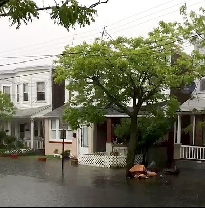
In Atlantic City, New Jersey, residents along one street deal with ankle-deep flood waters on a rainy day, with even higher floodwaters arriving with every new moon.
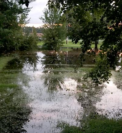
In southern Virginia Beach, Virginia, a bit of rain and a strong wind from the south is enough to bring water from the Back Bay onto farmland.
And in Norfolk's Hague neighborhood, high tides spill water from the Elizabeth Creek into the streets, making roads impassable, damaging cars and snarling traffic.Flooding has become so common that Norfolk resident Kiquanda Baker says residents will cancel plans if rain is in the forecast.
"It's becoming where people have to plan around water," Baker said.
Those in the Chesapeake Bay area say that flooding has become an increasingly persistent problem in the last two decades. Scientists say that things will only get worse, as the area is ground zero for rising seas on the East Coast.
Sea levels have risen across the entire coast, but nowhere as high as in the Mid-Atlantic region. And experts say the trend will only accelerate because of climate change, putting coastal residents from North Carolina to New Jersey at increased risk of flooding.
From 1900 to 2017, sea levels rose about a foot and a half along the Chesapeake Bay, compared to one foot in New York City and Miami, according to a December 2018 study by researchers at the Woods Hole Oceanographic Institution in Massachusetts.
Scientists say there are multiple causes for the rise in sea levels. The Virginia Institute of Marine Sciences points to melting ice in Greenland and Antarctica and changing ocean currents. Researchers at Woods Hole attribute the differences to "post-glacial rebound," or the way the earth's surface has slowly re-arranged itself since the end of the last ice age.
But they all say that it will only get worse.
#embed-20181227-sealevel-ai2html iframe {width: 1px;min-width: 100%}
Chris Piecuch, the lead researcher for the Woods Hole study, says sea rise is a particular danger for those in the Mid-Atlantic.
"Climate change is warming sea temperatures and raising sea levels everywhere, but folks in places like North Carolina have a double whammy," Piecuch said.
Higher waters pose multiple risks, experts say. Coastal regions can flood at high tide, even on sunny days. And during rainstorms, backed-up drainage systems can inundate inland areas.
"If you get a really heavy rain event and the storm sewer is closed off because of the high tide, the rain can't drain," said Molly Mitchell, a marine scientist at the Virginia Institute for Marine Sciences.
The effects are already being felt in cities along the Chesapeake Bay, like Norfolk, where rain will snarl Tidewater Drive, a major north-south roadway, said Baker, the resident who works for the nonprofit Chesapeake Climate Action Network in Norfolk.
But, the problem isn't confined to rainy days. "We have sunny day flooding where half of my office is surrounded by floodwater," Baker says.
In Virginia Beach, residents who survived a direct hit from Hurricane Matthew in October 2016 created a Facebook page to pressure officials about repeated flooding in the area. The page has since attracted more than 1,700 followers.
One resident, Conrad Schesventer, who ran an unsuccessful bid for city council last year on a platform of modernizing the drainage system, said floodwaters can rise so quickly that his car has flooded after only a few minutes of heavy rain.
"This wasn't related to any tropical system. It's just a heavy thunderstorm," Schesventer said. "Stuff like that we didn't use to see."
Melissa Stillman's home in Virginia Beach's Bird Neck neighborhood sits 6 feet above sea level. Homes in her area have drainage ditches that feed rainwater to a nearby creek.
During the rainy summer months, streets around the neighborhood flood up to four times a month, Stillman said. And flood waters are getting closer to her home than ever.
"This is the first year that just during a heavy rainstorm the water was backing up in our yard, getting close to our house," Stillman said.
In Pungo, a neighborhood in southern Virginia Beach, locals are wary of winds. Pungo is one of several neighborhoods in the area that suffer from flooding when winds come in from the south, blowing water from the Back Bay into streets and onto properties.
Suzee Ferg, who has lived in Pungo for 30 years, said that wind causes floods in the area at least once a month, in addition to weekly rain-related floods.
"I've had water over 3 feet at my back door six times," Ferg wrote NBC News via Facebook Messenger. "Emergency vehicles can not get in. The school bus will not enter the road. If you don't have a lifted truck, you're not getting out."
Up the eastern seaboard in Atlantic City, flooding has long been a problem. Poverty makes its residents particularly vulnerable, and the city has been slow to recover from the financial crisis of 2008.
Unemployment is nearly twice the statewide average, and 40 percent of the population is below the poverty level. The city's dire finances prompted the state to take over financial operations of the city in 2016.
On Arizona Avenue, a lower-income residential block a half mile from the boardwalk, homeowner Chris Macaluso said he and his neighbors deal with constant flooding.
"It floods during moderate rain," Macaluso said. "Floods during new moons. Floods when there's nor'easters."
In photos and video Macaluso shared with NBC News, residents and cars can be seen wading through tire-high waters. Front steps are submerged and foundations are damaged.
After Hurricane Sandy tore through in 2012, the federal government poured resources into the area. In May, the U.S. Army Corps of Engineers finished a $38 million, 99,000-ton seawall and boardwalk along the city's northeastcoast.
But Macaluso said nothing has been done to protect Arizona Avenue.
"This flooding isn't new. It's been going on for years," he said.
Local governments have long been aware of the issue. In Virginia, the state legislature tasked the Virginia Institute of Marine Sciences with producing a report on sea levels in 2012, which the institute released the following year.
Since then, Mitchell, the scientist at the institute, said that several cities along the coast have invested in raising roads. Two-hundred miles north, outside of Washington, the city of Alexandria has invested heavily in improving drainage in its Old Town neighborhood, Mitchell said.
Virginia Beach used the institute's projection of 18 inches of rising sea level to help guide its flooding response plan. Deputy City Manager Tom Leahy told NBC News that the city is in the final stages of two studies: one to assess the drainage system and the other to look at how the sea level rise will affect the city.
Farther north in Cape May, New Jersey, the county emergency management department unveiled a real-time flood map in December that lets readers preview expected flooding down to the street level.
Proper planning and investment will be enough to combat the rising seas, Mitchell said, but only if governments and residents act.
"Things are going to be different, but that can be OK," Mitchell said. "It's only going to be a crisis if we don't change anything."


