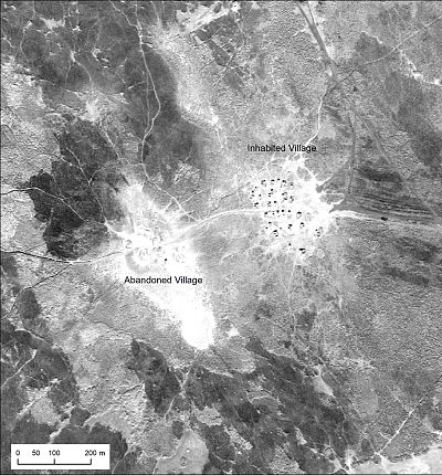
The images offer a vast trove of information about ancient villages and agricultural sites.
The Cold War may be over, but spy photos from the era are now a hot commodity with archaeologists.
 ADVERTISEMENT
 ADVERTISEMENT
During the 1950s and the 1960s, American U-2 spy planes flying top-secret missions over the Middle East, Eastern Europe and the Soviet Union snapped countless high-resolution photographs of military installations on the ground below.
But the photos, which were declassified in 1997, contain a vast trove of visual information about ancient villages and agricultural structures — including some in places that are now too dangerous to visit in person and others that may have been destroyed in recent decades.
"The planes were flying over these areas of intelligence and geopolitical interest — things like airfields in the middle of nowhere in Syria," said Emily Hammer, an assistant professor of archaeology at the University of Pennsylvania. "But they passed over a lot of other places on their way to their main targets, and they had their cameras on while they were doing that."
Hammer is co-author of a new study, published March 12 in the journal Advances in Archaeological Practice, that used the black-and-white images to get an unprecedented look at Bronze Age villages and 3,000-year-old irrigation canals in southern Iraq, and prehistoric walled structures known as "desert kites" that were used as hunting traps in eastern Jordan.
The photos taken by the U-2 spy planes capture objects on the ground with remarkable detail even though their cameras were routinely used at altitudes as high as 70,000 feet — almost twice as high as commercial airliners fly. "Cameras in the 1950s were just as good as they are now — they just weren't digital," Hammer said.
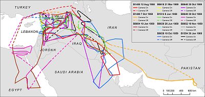
For their research, Hammer and her collaborator, Harvard anthropologist Jason Ur, cataloged photos from 11 separate U-2 photo reconnaissance missions over the Middle East during the 1950s and the 1960s. The photos were not indexed in any way, forcing the pair to unspool hundreds of feet of film, photograph them to create digital copies, and then carefully stitch the frames together to recreate the flight paths of the spy planes.
"There was no way to search by keyword or anything, much less figure out what photos might cover a particular area that you're interested in," Hammer said. "We built a spatial index where people can go to a place on a map and see if a U-2 plane flew over this area, and see if its cameras were on at the time and if it took pictures, and the date of those pictures."
And there may be plenty more U-2 photos for archaeologists to pore over.
"For every chunk of material that has been declassified, there is more out there that has not been declassified or has not been thoroughly examined," said Michael Harrower, an archaeologist at Johns Hopkins University who wasn't involved in the new study. "There may very well be lots of new things to discover in that archive."
In addition to studying ancient sites, Hammer hopes the U-2 archive will be useful for people who are monitoring archaeological sites in conflict zones, particularly in places that have suffered destruction in recent decades.
"What we see in these photographs is no longer there, which is the case with archaeological sites, but more critically and more tragically, these images preserve a record of a place like Aleppo that has been completely destroyed just in the last 10 years by the Syrian civil war," Hammer said. "So it's not just about the deep past, but it's also about accessing something that was very recently there but is no longer."
Want more stories about archaeology?
- These technologies are giving new life to the ancient world
- Scientists find Civil War-era fortifications buried under Alcatraz prison
- How particle physics is shining new light on ancient secrets
SIGN UP FOR THE MACH NEWSLETTER AND FOLLOW NBC NEWS MACH ON TWITTER, FACEBOOK, AND INSTAGRAM.


