














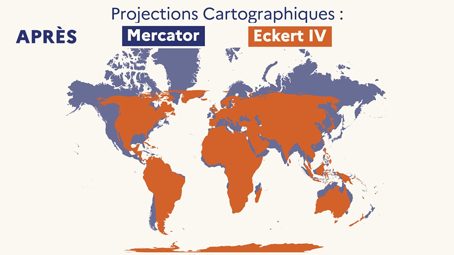













France is redrawing its world map: deeming the Mercator projection misleading, the foreign ministry will drop it in favour of a map that better reflects actual continental sizes, especially Africa.
A shrunken Africa, a Greenland and a northern Russia that seem to stretch into infinity: that is about to disappear from the maps used by French diplomacy.
 ADVERTISEMENT
ADVERTISEMENT
ADVERTISEMENT
Foreign Minister Jean-Noël Barrot announced on Friday that his department is abandoning the so-called Mercator projection, which artificially enlarges polar regions and visually downplays the size of equatorial areas. France will now use instead the Eckert IV projection, which reflects the true proportions of the continents more accurately.
As a result, France will appear smaller on the map compared with countries close to the equator, just like the United States or Russia.
"A map is never entirely neutral"
In a speech at the Sorbonne during the public event "La Fabrique de la diplomatie", the French minister said that "the time has come" to "correct" how the world is perceived through maps inherited from 16th-century Western navigators.
In a speech delivered at the Sorbonne for the public event "La Fabrique de la diplomatie", the French minister said that "the time has come" to "correct" how the world is perceived through maps inherited from 16th-century Western navigators.
"A map is never entirely neutral. Take the Mercator projection, the one every one of us has known since childhood. The areas we see on it do not correspond to actual areas: (...) The United States, Russia, China take on a disproportionate visual importance compared with Africa, Latin America or South-East Asia," the French foreign minister said.
Jean-Noël Barrot also cited the example of Greenland, which is roughly the same size as the Democratic Republic of Congo or Algeria, even though it "seems almost as vast" as the entire African continent.
"Changing the map obviously does not change the world. But correcting a representation that distorts it is already an act of truth," he stressed.
At the UN, a cartographic victory for Africa
The announcement in Paris comes as, in New York, the world map is also being redrawn. A few hours later, the United Nations General Assembly officially abandoned the Mercator projection in favour of a projection based on the Equal Earth model, created in 2018 and closer to the real proportions of the continents.
The non-binding resolution, entitled "Correcting the map" (source in French) and sponsored by Togo, was backed by 164 member states. The African Union had already adopted Equal Earth in March, and the text now encourages countries to do the same.
Only the United States voted against, denouncing what it called a "radical ideological project", notably because of a passage in the resolution stating that "correcting cartographic distortions relating to the size of continents constitutes an act of cognitive justice and memorial reparation".
Six countries – Estonia, Georgia, Lithuania, Moldova, Serbia and Ukraine – abstained.
The UN stresses that the resolution does not ban the Mercator projection, "nor does it impose a single map". The resolution "encourages governments, educational institutions, international organisations and technology companies to make use of the Equal Earth projection (source in French), or of other so-called 'equal-area' maps that preserve the true proportions of surface areas.
France has therefore joined this movement, but has opted to adopt the Eckert IV projection, created in 1906. It is similar to the Equal Earth projection recommended by the UN, though not identical. Both represent the size of the continents much more faithfully than the Mercator projection, but they differ slightly in the shapes they give to the landmasses.
As the UN points out, Mercator mapping will not disappear altogether. Digital platforms such as Google Maps also currently use (source in French) a version of this projection.
In French schools, most world maps are still in Mercator. "You can find Eckert or Peters* in some textbooks, but that is very rare," says Grégory, a senior history and geography teacher in Rennes, speaking to Euronews.
It remains to be seen whether the maps used in schools will also follow the shift launched by the foreign ministry.
*another equal-area projection, which provides a better representation of the continents' true surface area – Euronews.