


Observation, alert and assistance systems for geological risks are being reinforced on Europe’s Atlantic coast, thanks to the AGEO project. In the Canary Islands, citizens can help by reporting a landslide on an app, which notifies others of road closures.
Rainfall and erosion linked to climate change threaten our coasts. Europe’s Atlantic coast is particularly exposed to landslides, floods and other high-impact geological risks, as is the case in the Canary Islands. Monitoring them and strengthening cooperation between civil society and the authorities are priorities for AGEO, the Platform for Geological Risk Management in the Atlantic, a project that has brought together experts from five European countries.
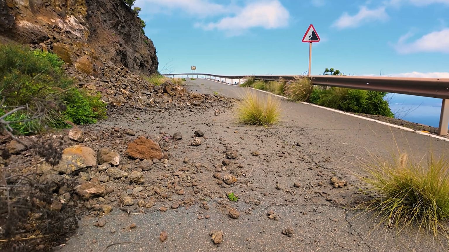
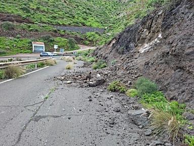
On the Spanish island of Gran Canaria, for example, rockfalls are very frequent. In December and January, they have been practically daily occurrences, according to Enrique Sánchez Déniz, head of the drone unit of the General Directorate of Emergencies of the Government of the Canary Islands. “With the bouts of rain, there are more cases of landslides and on some occasions, large stones have taken away some cars. What AGEO is providing us is greater knowledge in these situations and the ability to know what measures to take at that moment.”
In Gran Canaria, the GC-60 road is the most touristic on the island. It’s also one of the busiest and most exposed to landslides. On this road, the municipality of San Bartolomé de Tirajana has integrated geological risk into its Municipal Emergency Plan. Thanks to it, citizens are alerted to possible landslides in real time… and they can also report them.
Santiago Mejías Ramírez, from the San Bartolomé de Tirajana fire service, emphasises the importance of rapid alerts, especially in cases where there are no alternative secondary routes. In those cases, he says, "We often prefer that people remain confined to their homes until the road is cleared and safe access is guaranteed."
The key elements: innovation and citizen science
The regions where the AGEO pilot projects are being carried out have the Copernicus program to monitor and accurately determine geological risk zones in real time. In addition to the eyes of the satellites of the European space program, there is another perspective: that of citizens.
It's collaborative science: if a person witnesses a landslide, they can alert others with a simple phone call; or with geolocated and dated photos, via an application.
AGEO has strengthened data sharing between citizens, authorities, emergency teams and scientists, and has allowed for the updating of risk maps.
In the Canary Islands, AGEO has three pilot projects in La Palma, El Hierro and Gran Canaria. According to Isabel Montoya Montes, researcher at the Geological and Mining Institute of Spain (IGME) and professor at the University of Las Palmas de Gran Canaria (ULPGC), "The process has brought people closer to the community. How a landslide works, why it occurs, what the causes are, and making them aware that they can help improve risk management systems. It is very important, in the case of landslides, to have up-to-date maps of where they have occurred.”
Raising awareness about geological risks also takes place in classrooms. Students at the Faro de Maspalomas high school learn in class that their island is a risk zone for several reasons, including seismic activity. Aythami, 15, was impressed by the display in the courtyard of drones equipped with infrared cameras, spotlights and speakers. “Now you know what to do if you witness a rockfall. First, if I see that there is already some movement (of earth, ed.), I move away and then I call the fire department in case there is anyone who may get stuck later, I would call 112. I've been surprised by the resources used, especially to save people," he says.
AGEO's total budget exceeds €3.2 million, of which 75% has been financed by the European Union's Cohesion Policy. Portugal, Spain, France, the United Kingdom and Ireland have participated in the project, which won two awards in the latest edition of the "REGIOSTARS Awards", a European award that recognises the excellence of projects funded by the European Union.