


The European Commission has confirmed that El Niño is almost certain this year, which could affect Europe. Speaking to Euronews, climatologist Carlos da Camara warns of a possible heatwave and major wildfires in Portugal.
El Niño is on the way, but its direct effects on Portugal will be very limited, according to information from the Portuguese Institute for Sea and Atmosphere (IPMA).
The European Commission, through the Joint Research Centre (JRC), is the latest international body to say it is "virtually certain" the phenomenon will recur this year, probably lasting until 2027.
According to the JRC report, El Niño is expected to reach a "very high" intensity, probably hitting a "very strong" level and potentially surpassing historical precedents such as the event 12 years ago. The European Commission warns in particular of the food risks associated with drought, which comes on top of already high energy and fertiliser prices and could put "hundreds of millions of additional people at risk". Adverse weather conditions could hit key crops such as durum wheat, which may be the most affected, as well as maize, rice, soya and winter wheat.
The World Meteorological Organization (WMO) issued a warning earlier this month (source in Portuguese), saying there is an 80% probability that an El Niño event will develop between June and August this year, meaning an abnormal rise in sea surface temperatures in the Pacific Ocean, with direct consequences for tropical and subtropical regions worldwide and possible indirect effects in many other parts of the globe. More recent forecasts say the consequences of this event, which is expected to have "moderate to strong" intensity, have a 90% probability of lasting until the end of the year.
The WMO information was also disseminated by the UN (source in Portuguese), accompanied by a video from Secretary-General António Guterres, who said: "The world must treat this threat as a climate alarm bell. El Niño will further intensify global heating. Its impacts will be more severe, will reach further and will cross borders at devastating speed."
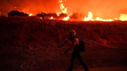
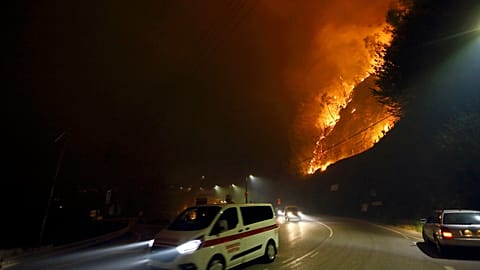
Portugal is far from the Pacific, but that does not mean it is shielded from the impact El Niño has on temperatures. A hot summer means the need for heightened vigilance, not only regarding the health effects of heat, especially for people working outdoors, but also in relation to wildfires.
According to the IPMA, in a note released (source in Portuguese), "although El Niño occurs in the Pacific Ocean, it can influence climate patterns on a global scale. However, its effects in Portugal are neither direct nor straightforward to predict."
What impact will it have on Portugal?
For climatologist Carlos da Camara, the occurrence of the phenomenon in the context of climate change could be an explosive cocktail and have consequences for Portugal, albeit indirect ones.
For this senior researcher at the Dom Luiz Institute, the effects of El Niño can be compared to throwing a large stone into a pond, creating concentric ripples that gradually lose strength as they spread: "The phenomenon starts in the central Pacific. The disturbance extends over the American continent, both north and south, then reaches Indonesia and continues from there. It eventually has an influence on southern Africa and then spreads over Canada before it starts to die out, meaning the direct influence on the European continent is small, very small. In particular on the Iberian Peninsula, it is smaller still," he explains.
However, even if the direct consequences are scant or virtually nil, the phenomenon’s "butterfly effect", combined with current conditions, could have indirect consequences for Portugal this summer, especially in terms of wildfires.
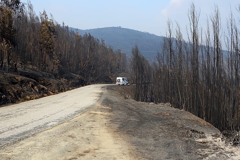
In Mediterranean Europe, which he considers one of the parts of the world where climate change is being felt most intensely, the impact could be amplified. "My concern is that there may be a heatwave like the one in 2003, which was the most severe heatwave ever recorded in Europe," the scientist says. "If that happens, given that we had that sequence of storms linked to the Kristin depression which brought down millions of trees, we know we now have much more biomass available to burn, not only because we had a very rainy spring, but also because of this excess biomass from fallen trees. We could, for example, see a large-scale wildfire, and that in a very tricky time of year," he explains.
Could such a heatwave arrive as early as next week? The IPMA is forecasting very high temperatures from the weekend, with values that could exceed 40°C in several inland areas. Some private models even predict that thermometers could reach 50°C. For Carlos da Camara, "that figure represents an upper threshold with a high degree of uncertainty".
As for whether the 2003 level could be reached in the coming days, the climatologist says he does not yet have enough information to say.
Carlos da Camara sums up the possible effects as follows: "Will El Niño have direct influences? No. Indirect influences? Very probably, yes. Indirect influences on top of a background that has been worsened and degraded by climate change, which can lead to much greater impacts? The answer is yes, certainly. Ultimately, the problem is not El Niño itself – for other regions it is, for north-eastern Brazil it certainly will be, for South Africa it certainly will be, for Indonesia too. For Europe probably not, but indirectly it very well might be."
What is El Niño?
Contrary to what some people think, this phenomenon is neither new nor recent, and it is not caused by climate change, although global warming can amplify its effects. The term was first used in the late 19th century in Peru to describe the warming of Pacific currents that frequently occurred around Christmas.
More recently, meteorologists have begun linking this phenomenon to a whole range of extreme weather events that can occur at the same time as "El Niño". One example came in 2014 and 2015, when the "El Niño" confirmed by the WMO was accompanied by severe droughts in several regions of the world, which badly affected agriculture and increased the risk of food insecurity in parts of the globe that were already particularly fragile.
According to scientists, the "El Niño" expected to begin this summer could have consequences as serious as, or even more serious than, the one that occurred 12 years ago.
The phenomenon began to be studied in more detail by meteorologists with the creation of a scientific framework known as ENSO, short for "El Niño Southern Oscillation", which measures temperature fluctuations in Pacific waters and predicts both El Niño and the opposite phenomenon, the cooling of the currents, known as "La Niña".