

















Although the intense weather phenomena eased during the morning hours, emergency services remain on high alert, as further rain and thunderstorms cannot be ruled out during the day.
A new wave of severe weather is affecting several parts of Greece, with heavy rain and thunderstorms expected on Monday and Tuesday, mainly in the west of the country and the islands of the eastern Aegean.
 ADVERTISEMENT
The severe weather caused serious problems and extensive damage on Rhodes in the early hours of Monday, with the heaviest rainfall occurring mainly in villages on the eastern side of the island.
The intensity of the weather phenomena was particularly high during the night, with water flooding roads and creating dangerous conditions for residents.
The area of Archangelos was hit hardest, where the overflowing of a river turned roads into torrents.
Cars were swept away by the rushing water, while shops and other business premises suffered damage.
The situation caused major disruption in the area, with residents facing the consequences of the severe weather and teams from the competent services working to deal with the problems.
Flooding was also recorded on a smaller scale in the Afantou area, as well as in villages in southern Rhodes, where the heavy rainfall created problems on the road network.
From the first hours of the onset of the bad weather, Civil Protection services in cooperation with crews of the South Aegean Region and the Municipality of Rhodes, were mobilised to tackle the problems.
Efforts are focusing on removing vehicles that were swept away by the water, cleaning drains and restoring the flow of water in streams and points where obstacles have formed from debris.
At the same time, interventions are being carried out on the road network in order to restore traffic and reduce the risks for residents.
Although the intense weather phenomena eased during the morning hours, emergency services remain on high alert, as further rain and thunderstorms cannot be ruled out during the day.
Message from 112 and closed schools
Earlier, a warning message via the emergency number 112 was sent in the early hours of Monday to residents and visitors on Rhodes.
In the message, Civil Protection called on citizens to limit their movements and to follow the instructions of the local authorities, in order to avoid danger from the occurrence of severe weather phenomena.
At the same time, by decision of the local authorities, schools in the municipal units of Archangelos and Afantou on Rhodes will remain closed on Monday because of the adverse weather conditions.
The decision has been taken for preventive reasons, with the main priority being the safety of pupils and teachers, as well as avoiding unnecessary travel in the current weather conditions.
As underlined in the announcement issued by the Municipality of Rhodes, the protection of the school community is the priority, so that potential risks are avoided during travel to and from school premises.
Kalymnos: Large boulder breaks away and crashes into garage
Problems caused by the bad weather were also recorded on Kalymnos, where heavy rainfall led to a large rock breaking away in the area of Agios Vasileios, creating a serious risk for homes located below.
As the mayor of Kalymnos, Giannis Mastrokoukos, told the Athens-Macedonian News Agency, the boulder broke away from the slope and as it fell it crashed into a garage, damaging the car parked inside.
"If the garage had not stopped it, below there is a cluster of houses. And no one knows what would have happened," Mastrokoukos said, describing the seriousness of the incident.
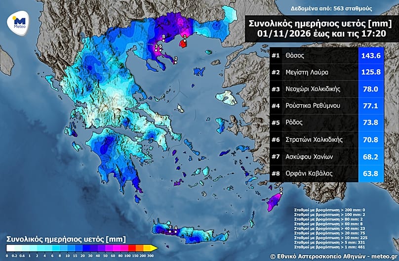
The course of the bad weather and rainfall totals
On Monday, the most intense phenomena will occur in the Ionian Islands, mainly in its northern parts. From the afternoon, heavy rain and thunderstorms are expected in Epirus, Western Central Greece, as well as in the western and southern Peloponnese.
InAttica and Thessaloniki, rain is expected at times, without particular intensity.
Tuesday is expected to be the last day with intense weather phenomena, as from Wednesday the weather will improve significantly.
On Sunday, heavy rainfall occurred mainly in Central and Eastern Macedonia, the Dodecanese and Crete, according to the National Observatory of Athens/meteo.gr.
Specifically, by 17:40 the greatest cumulative precipitation height was recorded at Limenas Thasou (144 millimetres), while more than 125 millimetres fell at Megisti Lavra in Mount Athos.