


Israeli air strikes have flattened entire neighbourhoods in northern Gaza. Whole rows of apartment blocks simply disappear in satellite images revealed by space technology company Maxar.
Three weeks after the bombardment by Israeli forces, space technology company Maxar has released satellite images showing the extent of the destruction in Gaza.
The Palestinian death toll has risen to over 7,000 as Israel unleashes waves of devastating air strikes in response to a bloody Hamas incursion on 7 October that killed 1,400 people and took 200 hostages.
The air strikes have flattened entire neighbourhoods, causing a level of death and destruction not seen in the last four wars between Israel and Hamas.
More than a million people have fled their homes, with many heeding Israeli orders to evacuate to the south, despite ongoing Israeli strikes across the blockaded territory.
Whole rows of apartment blocks simply disappear in the photos, reduced to smears of dust and rubble.
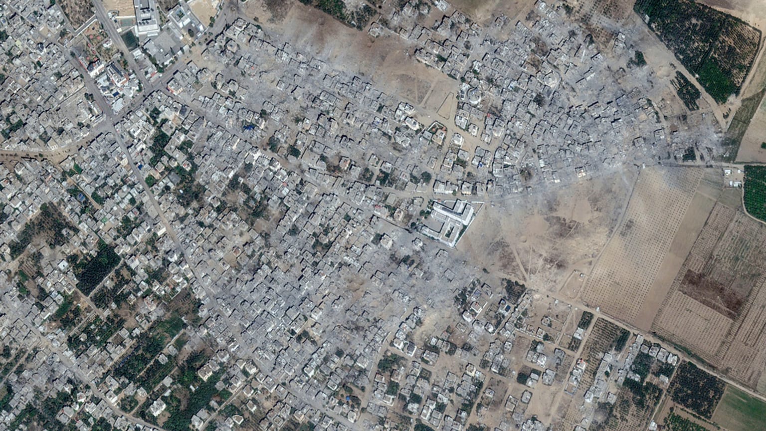
The town of Beit Hanoun in the northern Gaza Strip. The first is an image taken on 10 October, while the second is an image taken on 21 October.
Other images showing different points in Gaza have been released by Maxar.
A complex of 13 seaside high-rises near Gaza City's al-Shati refugee camp was blasted to dust, leaving only a few tottering pieces of facade, according to photos taken by Maxar Technologies.
The military says it only hits militant targets and accuses Hamas of operating among civilians to protect its fighters. The Israeli military said an airstrike killed one of the two masterminds of the 7 October massacre, Shadi Barud, the head of Hamas' intelligence unit.
Palestinian militants have fired thousands of rockets into Israel since the start of the war.
The satellite shows Atatra, a neighbourhood in the northern Gaza Strip town of Beit Lahiya. The first photo was taken on 10 May and the second on 21 October.
The Al Karama neighbourhood in the northern part of the strip is on the edge of the sea. The before picture was taken on 10 May, the after on 21 October.
In Gaza, supplies of food, medicine and fuel to power emergency generators are running low.
The UN agency for Palestinian refugees, which provides basic services to hundreds of thousands of people, including running schools converted into shelters, said it could run out of fuel within days.
The town of Beit Hanoun in the north of the Gaza Strip. On the right an image taken on 11 May, on the left one taken on 21 October.
In recent days, Israel has allowed more than 70 trucks carrying aid into Gaza from Egypt through the Rafah crossing, the only entry point into Gaza not controlled by Israel.
But aid workers say the convoys meet only a tiny fraction of the territory's growing humanitarian needs. Before the war, an average of 500 trucks entered Gaza every day.