On the road towards sustainable development and facing a changing climate, global economies increasingly need to rely on climate services to manage their risks. According to a recent Overseas Development Institute report, this is particularly true for the African continent, where many national economies and millions of livelihoods rely on agriculture. Unlike in Europe, African agriculture relies mostly on rainfall, which makes it highly vulnerable to climate variability. Droughts, floods, erratic rainfall, soil erosion, and lower crop yields are frequent across African countries, contributing to food insecurity and poverty and pushing people and economic sectors to factor climate variability and trends into their decisions.
But managing these hazards and lowering risks to lives and households, while continuing to develop infrastructure and industries, requires having access to real-time trustworthy climate information services. Across Africa, access to quality information remains insufficient, particularly in Sub-Saharan countries. According to research done in Ghana, that gap is there mainly because national weather and hydrological services use telecommunications networks that are “insufficient, ineffective, and outmoded and […] hinder the efficient delivery of observations and products, particularly to rural areas.” Other studies have observed that much of the research and effort towards delivery and using climate services, especially for Africa’s agriculture sector, have remained in pilot stage.
Solutions have been emerging. In the last few years, the Copernicus Climate Change Service (C3S) and ECMWF have been supporting the use of climate data to help tackle climate risks and inform decision makers across Africa.
Informing African agriculture
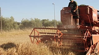
Across Africa, a continent which faces a generally low productivity for its food staples, domestic food production doesn’t keep up with internal demand, leaving countries to import most of their food and the population to pay about 60% of their disposable income to eat, shows World Economic Forum research. But managing low yields requires more information, such as better crop monitoring at field and farm level and accurate precipitation information which informs irrigation decisions.
“In Cameroon, only agro-industries formally factor climatic information into their activities,” says Dr. Kaah Menang, meteorologist and researcher with Cameroon’s National Department of Meteorology, who last year worked on a climate application tailored for countries in Africa with ECMWF support. “But they rely mostly on past local measurements, which have large uncertainties, of climate and weather elements such as rainfall, temperature, wind speed and sunshine. Future changes also have an impact, but they don’t take this into consideration, probably because they do not have access to climate projections data and/or do not know how to handle or process the data,” says Dr. Menang.
The “African Agro Climatic Indicators” application developed by Dr. Menang provides long-term past and future climatic information and is targeted at agroindustries growing biennial and perennial crops. The app, based on ECMWF’s ERA5 past climate dataset and on climate projection data from the World Climate Research Programme, helps farmers adjust farming practices and boost yields based on the climate data, but can also inform policymakers when making decisions for the sector.
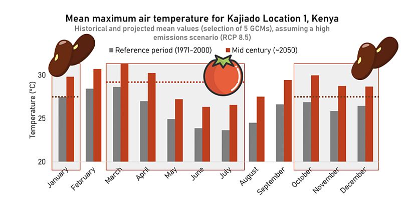
One CAS tool shows how future temperatures will likely affect the growing season of key crops. The dotted lines in this figure indicate the temperature threshold that should not be exceeded too often for tomatoes and beans. It shows that in 30 years, these thresholds are likely to be exceeded regularly in a high emissions scenario.
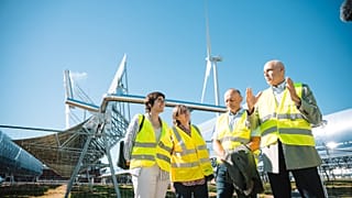
In Kenya, the Dutch foundation Climate Adaptation Services (CAS) has used data from the Copernicus Climate Change Service to provide more user-friendly climate information at farm level. The tools, build in collaboration with the Swedish Meteorological and Hydrological Institute (SMHI), Wageningen Environmental Research (WEnR) and the Jomo Kenyatta University of Agriculture and Technology (JKUAT) in Juja, Kenya, provide accessible maps and graphs that help farmers understand the probability of future climate change impacts.
“To determine farmers' needs we first organised multiple field trips and workshops with farmers,” says Sophie van der Horst, advisor for CAS. “We first presented them with basic climate data, such as average temperatures now and in 2050. However, we found out that this was not something that they could work with and that they needed more specific information. They needed more crop-related information. That is why we started to work with thresholds for growing seasons. We built an application in which you can insert a temperature threshold for certain months. So, for example, tomatoes grow well below 28 degrees and their growing season is between March and July. The application allows us to explore the number of days above this threshold for the current period and the future. As a result, farmers can get an indication on whether tomatoes will still grow well in the future or if they need to change anything (change crop, protect against heat, etc).”
Support for policy makers
Another tool providing tailored agro-climatic indicators based on C3S data is CLIMTAG, the CLimate InforMation Tool for AGriculture, developed by the Flemish Institute for Technological Research (VITO). The tool, developed in consultation with African key stakeholders, was created for agricultural policy makers and high-level decision making. “Policy makers can use this information to assist farmers in preparing for climate change directly by providing short-term support and relief measures and indirectly by adapting policy and steering the agenda towards incentivizing climate change informed agricultural practices,” says Jente Broeckx, business development manager at VITO.
As CLIMTAG allows a better assessment of climate information and climate impacts, it can inform adaptation planning for crop selection, cropping practices and timing which can ensure long-term climate resilient agricultural practices, Broeckx explains. The tool provides country-wide climate-related information, access to 50 different indicators, as well as month information and long-term subregional trends.
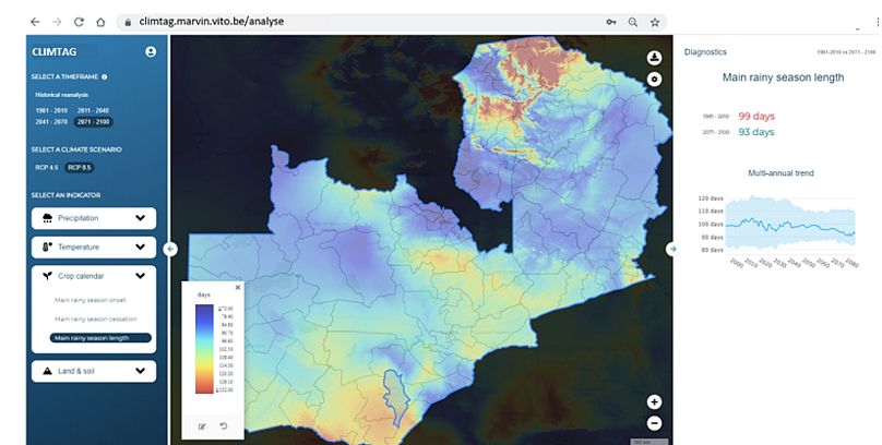
Starting with three pilot countries, Malawi, Mozambique and Zambia, the tool is now being upscaled for another 20 African nations. The expansion project, named KLIMPALA (Climate Platform in the Agricultural sector in Africa) aims to empower those working in agriculture to mitigate and adapt to climate change through tools, capacity building and coaching.
As the project will work with entrepreneurs and help them build climate resilience in their businesses, Broeckx says that this will help CLIMTAG reach more than policy makers. “Through this route information is directly disseminated to farmers, creating awareness and the opportunity for them to not wait for large-scale policy changes, but already prepare for and intervene in their day-to-day practices.”
Farmers could also get access to seasonal and shorter-term forecasts, as VITO plans to integrate more of their needs into CLIMTAG. “Covering the climate information at all time scales of the past and the future including short-term weather outlooks, seasonal forecasts as well as long-term climate scenarios in a consistent way will make it a more attractive tool for all levels from policy to on-the-ground and from short-term decisions to long-term planning,” says Broeckx.
Data for Africa’s water issues
Although Africa has 10% of the world’s freshwater resources and 12% of the global population, water is unevenly distributed on the continent, with an average of 86% of water withdrawals being used for agriculture. According to the World Economic Forum, the main reasons for water shortages in agriculture include evaporation as a result of high temperatures, inefficient storage of water reserves, and inefficient irrigation plans.
In South Africa, the Water Research Observatory, a project supported by South Africa’s Water Research Commission works as a data repository and as a platform for data processing, analysis, and visualisation. “Climate data is now not only being used in traditional hydrological and crop models to predict and prepare for the impacts of climate change, but also in artificial intelligence applications to gain additional insights into our hydrological systems,” says Michael van der Laan, water specialist researcher at South Africa’s Agricultural Research Council. “Accurate regional and up-to-date weather data is key in driving our models used for water management, for example, in identifying where and where not to build a dam or to track water pollution back up the river to its source.”
According to van der Laan, the WRO is currently working on building a tool that can sense remotely when aquifers are being over-exploited and is also using AI to develop models that can predict streamflow. “Precision agriculture equipment is being used to place thousands of mini experiments in commercial fields. Combined with weather data, forecasts and Sentinel 2 satellite imagery, farmers become more empowered to make better decisions in the use of their resources, for example, not to apply excessive amounts of fertiliser in a season when low rainfall is expected resulting in water-limited yields.”
Ultimately, improving climate information services in Africa will definitely need to continue to focus on the needs on the ground when moving from project stage to a real-life service.