
Scientists have mapped earthquake risk for the whole of Europe, giving tools to decisionmakers to build more resilient communities.
Scientists have created the first earthquake risk model for the whole of Europe which will form the basis for mitigation measures and making communities more resilient to the impact of natural disasters.
Earthquakes have been responsible for more than 200,000 deaths - as well as €250 billion in damage - in Europe during the 20th century.
Because it can’t be accurately predicted when and where they are going to take place in the future, areas at particular risk need to construct homes and buildings that can withstand earthquakes without taking too much damage.
European seismologists, geologists, and engineers have revised the existing earthquake hazard model for Europe that was first published in 2013, and have also created a earthquake risk model for the whole continent for the first time.
Earthquake hazard
The earthquake hazard describes potential ground shaking due to future earthquakes and is based on knowledge about past earthquakes, geology, tectonics, and local site conditions at any given location across Europe.
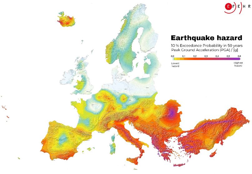
The team, led by members from the Swiss Seismological Service and the Group of Seismology and Geodynamics at ETH Zurich, says that with updated data sets the hazard model, they have a clearer idea of estimates for all parts of Europe.
Their model confirms Turkey, Greece, Albania, Italy, and Romania are the countries with the highest earthquake hazard in Europe, followed by the other Balkan countries.
First European earthquake risk model
The earthquake risk refers to the estimated economic and humanitarian cost of potential earthquakes.
With this information mapped out, the scientists believe decisionmakers have new valuable tools available to build more resilient communities, constructing buildings and architecture that can withstand the risks of earthquakes.
The models “provide authoritative information to inform national local decisions related to developing seismic design codes and risk mitigation strategies”, the team states.
They also point out the main drivers of earthquake risk are older buildings.
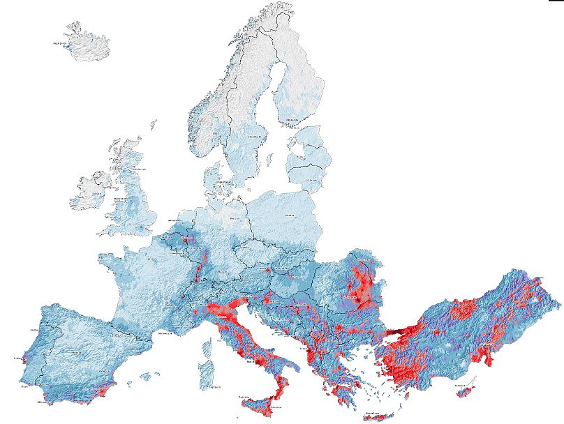
The risk is highest in heavily populated and constructed urban areas, such as Istanbul and Izmir in Turkey, Catania and Naples in Italy, Bucharest in Romania, and Athens in Greece.
All these cities have a history of suffering from damaging and at times catastrophic earthquakes.
Factors such as the age of buildings, population and building density, and local soil conditions can all contribute to earthquake risk.
And Turkey, Italy, Romania and Greece experience 80 per cent of the modelled average annual economic loss from earthquakes in Europe, which totals €7 billion.
Cities including Zagreb (Croatia), Tirana (Albania), Sofia (Bulgaria), Lisbon (Portugal), Brussels (Belgium), and Basel (Switzerland) also have an above-average level of earthquake risk.


