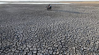
As more frequent river droughts will stretch the continent’s water resources, people, and economies must find new ways to adapt.
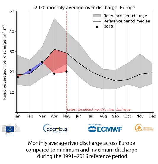
On 1 June 2018, results showed 4.5%. One month later, it was 10.8%; almost four months later, on 20 October, about 35.9% of Europe’s rivers were flowing abnormally low, the lowest since at least 1991. A summer of little to no rain left major water systems without their much needed water; repeated heat waves were also speeding up evaporation, leading to more water loss. This year, drought was already underway in April, in a big part of Central Europe, ranging from moderate to extreme, according to data from the Copernicus Climate Change Service (C3S) and in many regions the drought has continued throughout June, making 2020 the third year in a row with unexpectedly dry conditions, according to the Copernicus Emergency Management service.
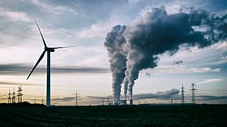
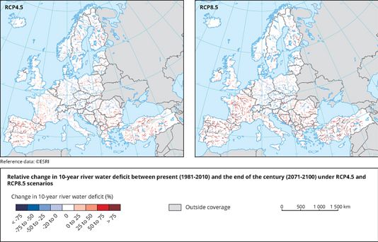
In the future, this might not be such an uncommon event. Halfway through this century, droughts are predicted to become more frequent, threatening a wide range of sectors, from water and energy supply to river transport and agriculture. “The Mediterranean sub-region, already suffering most from water scarcity, is projected to experience the strongest negative effects of climate change on drought conditions,” the Joint Research Center (JRC) Droughts Team told Euronews. “With increasing global warming, streamflow deficits in this region are expected to happen more frequently, become more severe and last longer,” the JRC team said. If global temperatures rise by 3 degrees, the researchers say an additional 11 million people and 4.5 million hectares could be annually exposed to droughts that used to occur only once every 10 years or so. “We see a strong divide within Europe, with more drought in the South and less in the North,” says Dr. Niko Wanders, hydrological extremes researcher at Utrecht University. “We’re observing that extreme droughts are likely to become more severe. This is caused by a combination of higher temperatures and more evaporation that results in bigger water losses,” says Dr. Wanders.
A noticeable factor comes from the fact that rivers are also receiving less water from glaciers, according to experts at the University of Birmingham. Warming in the European Alps in the last three decades, combined with less snowfall has resulted in a little bit under a 54% loss in glacier ice area since 1850; long-term predictions show further drastic reductions.
Rivers affected by drought lose more than water depth. Less rainwater means that river waters cannot dilute pollutants efficiently; this leads to higher concentrations of nitrogen and phosphorus, as well as of heavy metals and microplastics, according to experts from the MaRIUS research consortium. The organic build up boosts algal production, leading to blooms that could make the water unusable for human use. Hotter river waters also hold less oxygen than cold ones, which harms fish and other aquatic fauna.
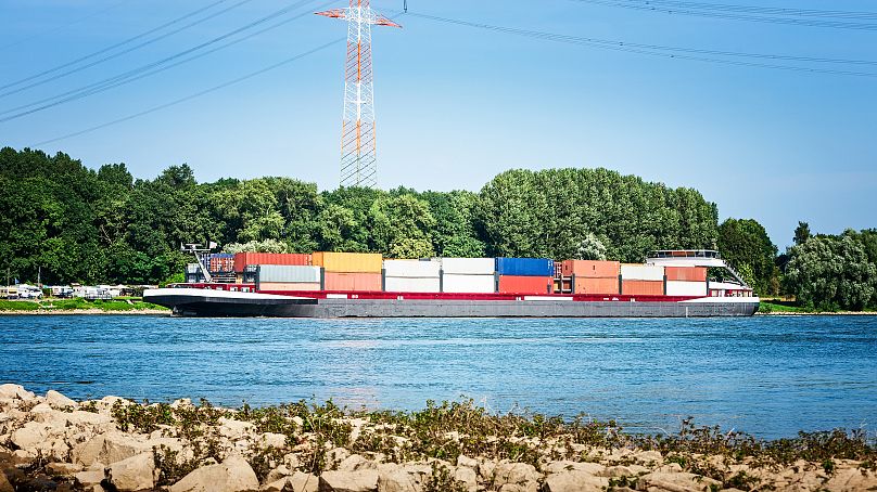
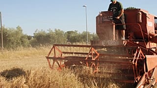
When water levels fall, businesses and livelihoods lose too. Electricity supply, agriculture, industrial production, water suppliers, and more depend on a steady inflow of freshwater to keep up with demand. In 2018, the Rhine River’s low waters made the waterway inaccessible for the major part of the fleet, in particular larger and newer vessels, on large portions, preventing major suppliers from shipping commodities and forcing companies across industries to cut production. Although this was a natural fluctuation of the river, says the Central Commission for the Navigation of the Rhine (CCNR), low river levels cause bigger economic impacts compared to the past, when industrial activity and shipping were less intense. According to a recent report, the shipping industry in Germany lost about 2.4 billion euros.
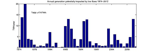
In the Netherlands, the 2018 record drought lowered groundwater levels, putting one million homes at risk from soil subsidence. In September 2003, following a lack of rainfall and high summer temperatures, the lower Danube river reached its absolute minimum since 1840. Ships and barges came to a halt, from southern Germany all the way to Romania, where its nuclear power plant shut down for almost a month as it lacked water to cool its reactors. In the UK, experts from MaRIUS estimate that over the last 40 years, about 4.6 TwH of power generation has been made impossible by low river flows, causing £45 million/year losses for companies.
Going with the flow?
If you take the worst climate scenario, economic losses from drought could increase by up to five times, shows a recent JRC study. But take mitigation measures, and that increase could be halved, the same paper says.
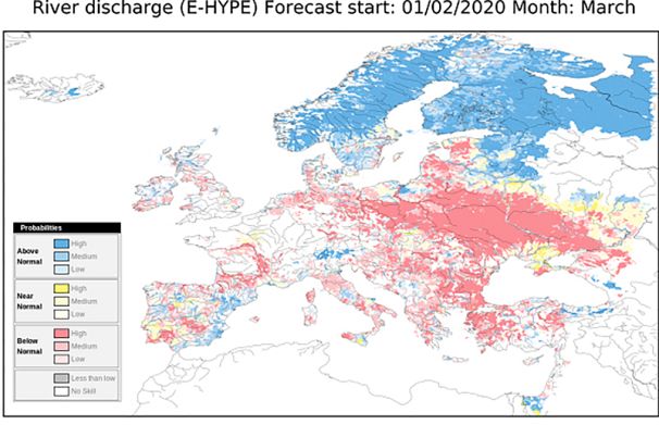
“Planning is key,” says Dr. Wanders. Improving water planning and management increasingly relies on climate information that helps predict when droughts might occur. “Proactive river management relies on drought forecasts; good real-time observations are key,” adds Dr. Wanders. Experts from C3S and SMHI are developing a service that would help authorities and businesses become more resilient to extreme events such as river droughts. The service uses hydrological models and regional climate models to provide water discharge projections over several months, as well as information on how climate change might influence rainfall and temperatures and river levels towards 2100.
“The key industries using hydrological forecasts are water resource and waste management, flood risk management, civil protection, hydropower, river transport, agriculture, and tourism,” says Dr. Shaun Harrigan, hydrological forecast scientist at the European Centre for Medium-Range Weather Forecasts (ECMWF). “Hydrological forecasts provide these industries with early warning of extreme events, when there is either too much or too little water in the river. This allows industry to be more resilient to hydrological extremes, making smarter decisions with positive socio-economic outcomes.,” Dr. Harrigan says.
Local authorities in the Mediterranean regions are aiming to better manage water resources in case of drought. In eastern Spain, water authorities in the Jucar River Basin, which supplies irrigation water to about 150,000 ha land, as well as to cities, hydropower, and industries, are using climate information from C3S to adapt water allocation to weather and runoff conditions and build resilience in a region experiencing ongoing drought since 2013. This activity aims to link climate and water data from across Europe to local data and support local authorities plan better in case of water scarcity.
Comunidad de Madrid’s water management company, Canal Isabel II, is acting on many fronts to tackle the region’s drying conditions, so as to provide water to more than 6 million people. “We have been suffering the consequences of water stress for some time; the average contributions of water to our reservoirs have dropped by almost 20% in the last thirty years, compared to the average since 1914,” the company’s representatives said. Apart from having back-up water sources, the company also uses models to predict water availability and plans to equip its reservoirs with early warning systems for extreme conditions. Canal Isabel also invested in wastewater regeneration that supplies urban and industrial uses and can reduce the amount of freshwater exploited.
In Italy, a consultancy company is providing digital tools for better water management. “We create services to forecast water needs and water availability seasonally and under climate change conditions for a wide range of users – irrigation authorities, water resource managers, energy companies,” says Dr. Paolo Mazzoli, technical director at GECOSISTEMA. The SmartRIVER service uses data from C3S and other providers, as well as site-specific data (i.e. from weather stations) to produce river flow and water availability forecasts tailored on users’ needs. “SmartRIVER is currently operational, forecasting incoming water volumes twice a month for the Ridracoli reservoir,” says Dr. Mazzoli. “This dam, built in the early 80's on the Appenines of Emilia Romagna Region, with roughly 30 millions m3 of water, provides drinking water to over 1 million people in four provinces,” says Dr.Mazzoli. “Using forecasts, the reservoir manager can optimise water usage and allocation.”
Accurately predicting river flows requires simulating the entire water cycle, Dr. Harrigan explains. “Traditionally, this was done at river basin level, where we had enough good quality weather and river flow observations. Now […] satellites allow us to make hydrological predictions in areas of the world where we have few or no ground observations,” Dr. Harrigan says. Uncertainties still linger though. “One of the largest uncertainties is forecasting extreme weather events that drive hydrological extremes, especially more than one or two weeks in advance,” Dr. Harrigan says. “The other is the ability to simulate what happens to rainfall when it seeps and travels through the ground. But innovations in remote sensing are most promising.”
Still, predicting river levels means looking at other factors too. According to the JRC experts, information on how much water is taken out for different purposes or on how groundwater extraction affects river flows is still missing. “The most challenging component of hydrological models is accounting for human interactions on the water balance, especially at large spatial scales. Improving our capability to model these factors will significantly reduce the uncertainty in drought monitoring and predictions,” says the JRC team.